MAPPING THE INTERACTION BETWEEN URBAN LAND USE AND TRAFFIC CONGESTION USING HETEROGENEITY INDEX
Abstract
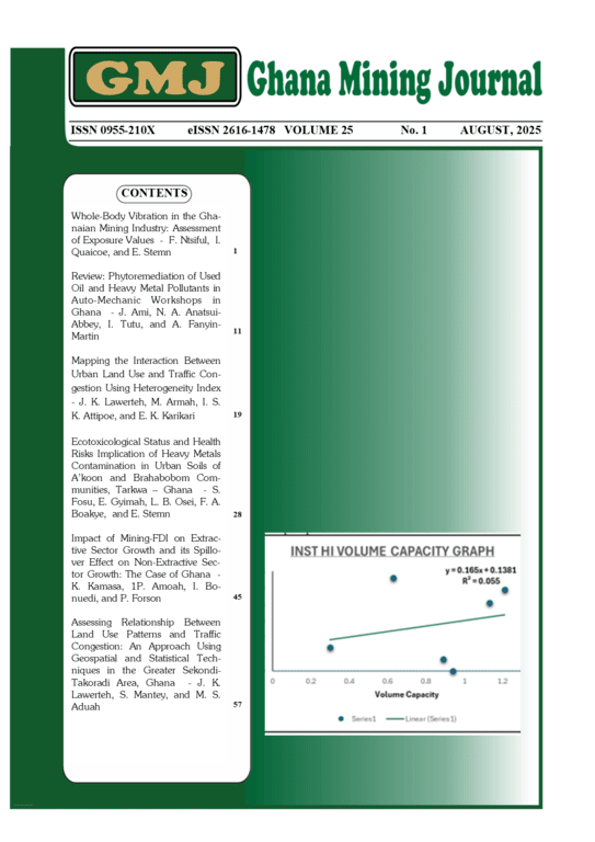
The interactions between urban landuse and traffic congestion has been well established by many reserachers over the years. However, assessing the impact of this interactions and its associated effect on sustainable mobility has been a challenge especially in developing countries like Ghana. Sekondi-Takoradi metropolis in Ghana has witness an increase in urbanization characterized by severe traffic congestions in recent years. The objective of this study is to develop and apply a heterogeneity index to determine the effect of hetrogeniety in land use distribution pattern on traffic congestions along six major roads in the Sekondi-Takoradi Metropolis. Vehicular traffic count survey was conducted on the selected study roads and the intensity of traffic congestion on each road was computed using Volume Capacity ratio (C/V). Six heterogeneity indices were established based on the fundamental land use categories in the research area. Analytical Hierarchical Processing (AHP) and knowledge-based weighting were utilized to prioritize the significance of various heterogeneity indices, while correlation coefficient was employed to access the relationship. Commercial land use had the most influence to traffic congestion as compared to the others with correlation coefficients of 0.512 while Industrial land uses had the least influence to traffic congestion with correlation coefficients of 0.157 on all 6 roads.The findings of this study indicates that the heterogeneity index, which measures the different land uses, has a substantial potential as an indicator of traffic congestion for a given location which could aid in traffic management and effective town planning.
Downloads
Published
Issue
Section
License
Copyright (c) 2025 Joel Kwabena Lawerteh, Mary Armah , Isaac Selasi Kojo Attipoe

This work is licensed under a Creative Commons Attribution 4.0 International License.
Copyright © 2021 University of Mines and Technology (UMaT), Tarkwa. Ghana
